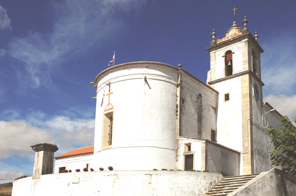
Nossa Senhora da Purificação Church| Bucelas
Building of Public Interest
Its Patron Saint is Nossa Senhora da Purificação. The temple was built in the second half of the 16th century – 1566 (date written on the door) and is of gothic, renaissance and mannerist architecture.
The interior’s decoration is mainly mannerist, according to the chequered tiles and the decorative paintings (flower compositions, volutes) in the bows and vaults.
Largo Espirito Santo
2670 Bucelas
Phone: 219 748 412
E-mail: executivo@jf-bucelas.pt
GPS: Lat.380 54´01,79” N Long. 90 07` 08,25” W Gr.
Santa Iria Church
The primitive building is from the 13th century, even though there are no traces of this era. The existing building is from the 17th century. Its interior is decorated with tiles that depict scenes from the life of Saint Peter.
The chancel has tiles from the 18th century that depict the tale of Santa Iria, paintings of the 16th century and two tablets from the 17th century.
Rua de Angola
2690-344 Santa Iria de Azóia
Phone: 219 566 303
E-mail: paraquia.santairia@gmail.com
GPS: Lat.380 50´44,91” N Long. 90 05` 12,91” W Gr.
Santa Maria de Loures Church | Loures
Classified as National Monument, the church was built in the 16th century in the same place where a medieval temple used to exist. Tombstones from this temple can still be seen in the churchyard that was used as a cemetery. Towards the end of the 17th century, it had a bell tower (1620), the clock tower (1680), the sacristy (1695) and a house of the Fellowship of the Blessed Sacrament. Nowadays, only the bell tower and the house of the fellowship, that is now used as a sacristy, remain. The Project of the church, of unknown author, shows architectonical characteristics of great erudition, as show the portals. The interior has three naves with bows set on columns decorated with vegetal motifs (brutish). The lateral altarpieces have paintings by Diogo Teixeira (1565-1612) and Simão Rodrigues (1583-1629), André Reinoso (1610-1641) and Bento Coelho da Silveira (1678-1708). The chancel was covered in the 18th century with inlaid marble of different colours and with an altarpiece of gilded wood, by the master Bento da Fonseca de Azevedo.
Largo da Igreja, Rua Fria, 1
2670-400 Loures
Phone: 219 831 782/219 833 176
E-mail: ictus.up@gmail.com
GPS: Lat.380 49´55,83” N Long. 90 10` 43,96” W Gr.
Santo Antão do Tojal Church
It was founded in the 13th century and reedified in1554 by the archbishop of Lisbon, D. Fernando Vasconcelos e Menezes, and rebuilt in 1730 by the first patriarch of Lisbon, D. Tomás de Almeida. In the front, the highlights are the image of Nossa Senhora da Conceição and a pediment topped with the archiepiscopal cross in the middle, the image of Saint Elizabeth of Portugal on the left and the image of Saint Bruno on the right. The bell tower, crowned on the four sides, has three bells from the 18th century. In the galilee, you will see the tile coating from the 18th century. The inside is simple as it was severely damaged during the First Republic.
Rua Padre Adrião
2660-119 Santo Antão do Tojal
Phone: 968 657 807
E-mail: ictus.up@gmail.com
GPS: Lat.380 51´04,79” N Long. 90 08` 26,51” W Gr.
Santo António Church | Moscavide
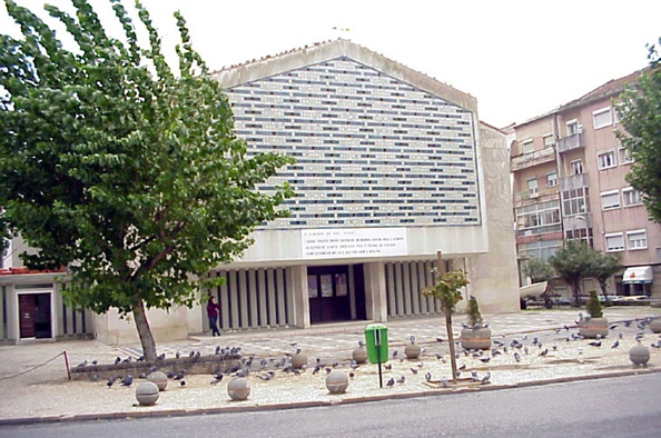
This Main Church, with modern lines, was built in 1855/56, at the time part of the movement of liturgical renovation. The front has Cargaleiro tiles and, on the inside, the highlights are a stained glass and a canopy, both by José Escada, a sculpture of Saint Anthony, sculpted by Lagoa Henriques and a modern style crucifix by Hélder Baptista.
Av. de Moscavide, 84
1885-063 Moscavide
Phone: 219 442 067
E-mail: paroquiademoscavide@gmail.com
Website: www.paroquiademoscavide.org
GPS: Lat.380 46´45,49” N Long. 90 06` 08,25” W Gr.
São João Baptista Church
This temple from the 16th century went through various changes through the years, as can be seen in the pyramid that crowns the bell tower from the 16th century and in the front from the end of the 18th century, beginning of the 19th century.
In the interior, with only one nave, the highlights are the font, the sepulchral slabs, the coats of arms with sepulchral inscription from the 16th century and the blue and white tiles that cover the chancel from the 17th century.
Rua da Igreja
2695-708 São João da Talha
Phone: 219 556 639
GPS: Lat.380 52´57,57” N Long. 90 09` 10,04” W Gr.
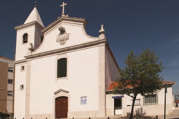
São Julião e Santa Basiliza Church | Frielas
The first reference to this temple is from 1191, though it was restored after the 1755 earthquake. The portal represents a neoclassical pediment (18th and 19th centuries). On the inside, with only one nave, with painted wooden ceiling, you will see the chancel with a vault cover.
Largo D. Fernando I
2660 Frielas
Phone: 219 884 366
GPS: Lat.380 52´57,57” N Long. 90 08` 31” W Gr.
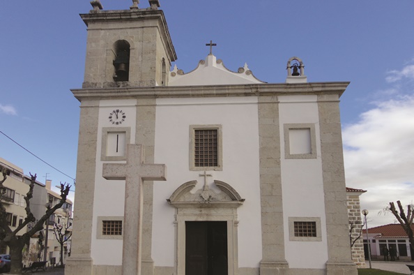
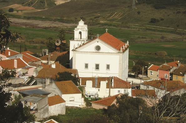
São Saturnino Church | Fanhões
This temple, with only one nave, is from 1575 and was restored in 1796, after the earthquake. On the inside, the highlights are the Saint John’s choir, set atop two marble columns, the font and the tile panels from the 16th and 17th centuries. During the Proclamation of the Republic, it was looted and burnt down.
Praça 5 de Outubro
2660 Fanhões
Phone: 968 657 807
Email: ictus.up@gmail.com
GPS: Lat.380 52´57,57” N Long. 90 09` 10,04” W Gr.
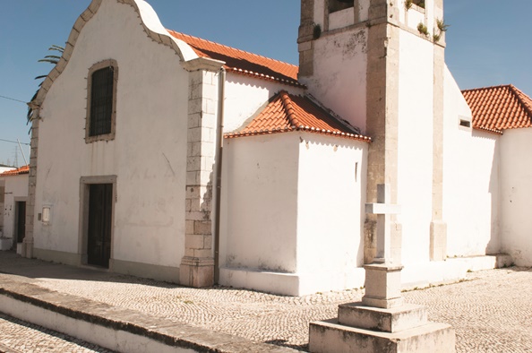
São Silvestre Church
In this temple from the 17th century, there are the archaic tower and the bell tower’s gothic door, that tell of an older foundation.
The interior, with only one nave, has a barrel vault. Take notice, at the entrance, of the tombstone and the tomb inscriptions from the 17th century.
In the chancel, the highlights are the gilded wood altarpiece from the 17th century and the two angels that hold the monstrance. The side altars have altarpieces also from the 17th century.
Largo de São Silvestre
2680-445 Unhos
Phone: 219 411 977
Email: luismag2@clix.pt
Website: www.paroquiaunhoscatujal.com
GPS: Lat.380 49´35,38” N Long. 90 07` 28,57” W Gr.
São Tiago Maior Church | Camarate
Building of Public Interest
This church has the name of the first missionary in the Iberian Peninsula. It was built over a chapel from the 14th century. The existing church is from the 17th century and has the structure and decoration of the era. It has an only nave and rectangular chancel. The nave has trough ceilings forming panels with figurative compositions and is covered with chequered green and white tiles. It has four side chapels with gilded wood altarpieces, interspersed in tribune with balustrade and pulpit on the evangel’s side.
Praça 1º de Maio
2680-124 Camarate
Phone: 219 471 579
Email: paroquiadecamarate@sapo.pt
GPS: Lat.380 48´05,01” N Long. 90 07` 45,88” W Gr.
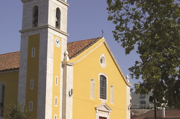
Santa Maria de Sacavém Main Church
This temple has Nossa Senhora dos Mártires e da Conceição as its Patron Saint. It belonged to the convent with the same name, having its construction started in 1596. It has only one nave with tiles in the king D. João V’s style that portray the mother of Jesus, manufactured in the Sacavem’s Chinaware Factory. The church’s original tiles portrayed Joseph of Egypt. The bigger bowl, made of marble, is said to have come from the house of the Alcaide Mouro.
Praça da República
2685 Sacavém
Phone: 219 410 345
Email: pnsp.sacavem@gmail.com
GPS: Lat.380 47´49,05” N Long. 90 06` 19,22” W Gr.
Cristo Rei Parochial Church | Portela
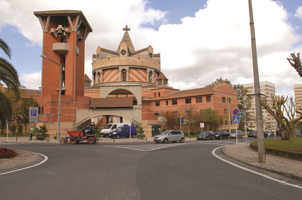
This temple, with modern lines, was inaugurated in 1992, and is the work of the architect Luiz Cunha. The summit looks like a regal crown and the bell tower has a carillon with 14 bells. The inside is made of a central body, with two more bodies with four floors each. Here, the highlights are the chapel of the Sacred, with the tabernacle inspired by a Greek temple; the 16 panels that tell the story of the salvation; the four central panels are inspired in the Book of Revelation; the font, where you can read “Fons Savatoris” – saving fountain; and images of St. John the Baptist, Crucified Christ, Christ the King, Luke the Evangelist, Mark the Evangelist, Anthony of Padua, Saint Jospeh and Saint Elizabeth of Portugal.
Av. dos Descobrimentos, 4
2685-194 Portela
Phone: 219 443 724 | 219 444 872
Email: cristoreiportela@gmail.com
GPS: Lat.380 46´53,74” N Long. 90 06` 37,73” W Gr.
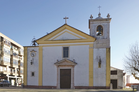
S. Pedro Parochial Church | Lousa
The oldest date that can be seen is 1546, inscribed in a side door in the Manueline style. It is a temple of simple lines that was restored in the 19th century. On the inside, the highlights are the high skirting with tile panels from the 18th century in the chancel that portray scenes from the Bible and two screens from that era that portray scenes from Virgin Mary’s life. The image of Saint Quiteria is also important.
Largo 5 de Outubro
2670-755 Lousa
Phone: 219 855 269
Email: paroquiadelousa@gmail.com
GPS: Lat.380 53´22,33” N Long. 90 12` 23,21” W Gr.
São Julião do Tojal Parochial Church
It is a temple with simple lines, with probable origin in the 17th century. It was built by order of churchgoers from the S. Vicente de Fora Monastery. The interior has tiles from the 17th and 18th centuries. The highlights are the image of the Holy Trinity in polychrome stone from the 16th century, the font from the 17th century, the screens in the sidewalls from the 16th and 17th centuries and the marble underground crypt with coat of arms framed in red marble from 1609 in the side chapel.
Igreja Paroquial – Largo da Igreja
2660-406 São Julião Do Tojal
Phone: 219 731 412
Email: ictus.up@gmail.com
Website: ictusparoquiasup4.webnode.pt/
GPS: Lat.380 53´22,33” N Long. 90 12` 23,21” W Gr.
CHAPELS
Nossa Senhora Conceição da Pedra Chapel
It is located in Freixial, next to the old Conde de Rio Seco palace, with a small bas-relief depicting Nossa Senhora da Conceição. In the 17th century, the chapel was expanded in the extension of the same building. The chapel has a portal crowned with a stone cross surrounded by two pinnacles. The interior seems to be a reconstruction of what would have been a temple with centred floorplan, as the chancel has the shape of a square whose sides are round arches. The walls are covered with blue, white and yellow tiles.
The temple has a structure in plastered and painted mixed masonry, showing a barrel vault in the salon area and cloister vault in the chancel. Lateral salient piers support all the system with entablature simply moulded with terracotta and mortar.
Rua Julie Mazens de Azevedo, 2, Bucelas
Phone: 219 748 412
Email: executivo@jf-bucelas.pt
GPS: Lat.380 52´57,57” N Long. 90 09` 10,04” W Gr.
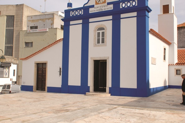
Nossa Senhora da Saúde e Santo André Sanctuary
The chapel is of uncertain date but older than 1599. Its primitive invocation was Santo André. It was a hospital for people sick with leper and served as housing for peregrines as well. The change to Nossa Senhora da Saúde is connected to the plague that hit Lisbon in 1599. It was ruined with the 1755 earthquake and was rebuilt in 1756 and later restored in 1872.
Rua Largo 5 de Outubro
2685 – Sacavém
Phone: 219 418 102
Email: geral@centrosocialsacavem.pt
Website: www.centrosocialsacavem.pt
GPS: Lat.380 52´57,57” N Long. 90 09` 10,04” W Gr.
CAMINHO DE FÁTIMA E SANTIAGO
The pilgrimage Way to Fátima and Santiago enters the district of Loures in Sacavém, through one of the doors of the Várzea e Costeiras Loures Park, from where it covers 5.8 kilometres, almost plain, beside the Trancão River, within marshes and old salt pans till it reaches the district of Vila Franca de Xira.
The quiet, the landscapes speckled with water, the diversity of birds, the agricultural fields where the olive tree still predominates, Sacavém’s Parochial Main Church and the view of the village of Unhos are some of the values that we invite you to appreciate in this section of the way.
HISTORICAL ROUT OF LINHAS DE TORRES
Recently recognized as National Monument, the Historical Rout of Linhas de Torres (HRLT) is one of the cultural and touristic products that invite the visitor to discover a unique patrimony in the history of Europe associated with the French Invasions, but also integrating many other interest points for those who cover it.
The HRLT is one of the offers that incorporate various experiences, from a tour of the patrimonial valuable places, to the degustation of wines produced in the region, to the pleasure of a rich gastronomy, to the fruition of the breath-taking landscapes!
The visitor can choose between the various itineraries articulated in net that cover a vast region, from the Tagus River to the Atlantic coast, supported in Interpretation Centres, that contextualize the visitor in the historical and social period of the patrimony that they visit. The fortifications of the military defensive system, localized in the district of Loures, are a part of the following circuits: Nó das Linhas, The Great Canyons, Alrota – Arpim e Ribas.
The visitors have the map and guide that let them choose one or more itineraries available to them, or they can obtain information at the various Interpretation Centres, as for example the one in Bucelas.
Interpretation Centre of the Historical Rout of Linhas de Torres
It is located in the building of the Wine and Vineyard Museum. This municipal equipment promotes, in an interactive way, the knowledge of the Peninsular War. Its goal is to preserve the history, culture and collective memory of a population that in the beginning of the 19th century, in war effort, rose to standard with the events and came together for a common cause holding a system of military fortifications in order to guaranty the defence of the city of Lisbon.
From this equipment, you will be able to visit the military structures that integrate the defensive system of Linhas de Torres in territory of Loures today.
Tuesday through Sunday | 10:00 A.M. » 01:00 P.M. | 02:00 P.M. » 06:00 P.M.
Closed on Mondays and national holidays.
Visitas gratuitas
Rua D. Afonso Henriques, 2 e 4 (EN 16)
2670-637 Bucelas
Phone: 924 487 297 | 211 150 669
Email: museu_vinho@cm-loures.pt; cilt@cm-loures.pt
GPS: Lat. +38° 54’ 06.21’’N, Long.-9° 07’ 12. 84’’ O
Forte do Arpim
This monument is located in the parish of Bucelas, in an area near the limit of the district that borders the district of Vila Franca de Xira. Its strategic position made it possible for a visual communication with other fortifications, namely with the set of Calhandriz and of Aguieira, in first plan, but also with the positions in Ajuda. This fortification was part of the First Line of Defence, being a position receded from the line and that, together with others, protected the territory between the Tagus riverside and the Calhandriz and Bucelas Canyons.
This fort has a polygonal floor plan surrounded by a moat and is practically in its entirety built in earth, except for the magazine. In its interior, there are five embrasures and an impressive magazine, in which the vestiges of where the wooden structures assented can still be seen, as well as the drainage system of the pluvial waters. On the outside, the highlight is the elbow slant that protects the access.
Coordinates: 38.912348, -9.082180
Ajuda Grande Stronghold
The Ajuda Grande Stronghld is located north of the parish of Bucelas, near the village Alrota, on a platform that enables the viewing of this vast area. It is an excellent scenic place and simultaneously it enables a strategic reading, which was the foundation of construction of this defensive system.
This country military work was part of the Second Line of Defence and belonged to the fortifications set that protected the territory between the Tagus River and the Bucelas Canyon, through the road from Vila Franca to Alverca and through the road from Sobral de Monte Agraço to Tojal, passing Arranhó and Bucelas.
This Stronghold has a complex floorplan, with two attached bulwarks and three accesses. It is surrounded by a moat, in some points dug in rock, and on the outside, there is an elbow slant that protects one of the north entrances. On the inside, there is a magazine, five embrasures and two slants, one of which in elbow shape, that reinforce the defensive dynamic of the entries.
Coordinates: 38.937985, -9.128836
Montachique Stronghold
The Montachique Stronghold, located inside the Cabeço de Montachique Municipal Park, had the strategic goal of guaranteeing the defence of the São Gião Canyon. Together with the Moinho stronghold, it assured the control over the Royal Road that started in Mafra. At the time of the Peninsular Wars, also known as French Invasions (1807-1810), the population of Montachique represented a strategic place because it was close to many fortifications and, for that reason, there operated a food provision point for the Anglo-Portuguese troops.
Coordinates: 38.905469, -9.185062
Ribas Stronghold
The Ribas Stronghold is a notorious country fortification, with a magnificent view over a vast region remarkably rural. Set at the top of the Ribas Sierra, it dominated the Freixial Canyon and the passable roads that at the time enabled the connection between Montachique and Bucelas. It is a notorious place where you can watch the surrounding landscape that in the beginning of every spring offers the possibility of contemplating various species of wild orchids.
This military work was part of the Second Line of Defence and established visual contact with many military positions, built in Nó da Malveira e de Montachique.
The Ribas Escarpment, located in the surroundings, is an example of the type of military work that aimed to reinforce militarily the natural barriers that were the reliefs. In the ridge of the Ribas Sierra, the artificial slopes can still be seen, in some places with the stone devices that accentuated the inclination with the purpose to prevent the climbing of the invader still preserved. This defensive military work exists from the Ribas Stronghold and the Mosqueiro Stronghold.
Coordinates: 38.895401, -9.162005
Mosqueiro Stronghold
The Mosqueiro Stronghold is also part of the Second Line of Defence and worked with a set of other military buildings that, with the Ribas Sierra, constituted a barrier against the advancing of the invader. This Stronghold has a polygonal floor plan surrounded by a deep moat that we invite you to walk during you tour of the place. The height of the counterscarp still gives a sense of security to those inside it. Near this place, you can see Cabeço de Montachique, the highest point in the District of Loures, and vestiges of a volcanic chimney that at the time of the French Invasions was used to implant a Communications Poll. The defensive system had not only a net of Military Roads that guaranteed the mobility and provisioning, but also a system of communication based on optic semaphores.
Coordinates: 38.898839, -9.182748
Mercearia Santana
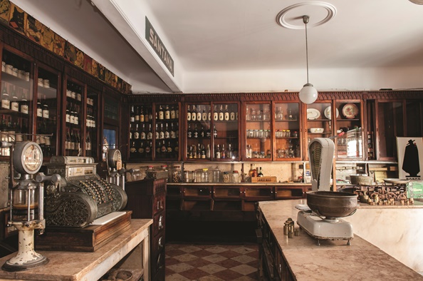
The building in Rua Almirante Reis number 41-43, in Sacavém, known as Mercearia Sanatana, is the property of António José Neves Montez. For more than 80 years, it was the residency of the family and a commercial place frequented by the local population. In 2015 a Collaboration Agreement was signed between the proprietor of Loures District Council with the goal of giving back to the building a new life, achieved through the programmes and activities of cultural, social and solidary character.
Activities:
Second Saturday of each month | 03:00 P.M. » 06:00 P.M.
Needs scheduling (48 hours previous)
Free tours
Rua Almirante Reis, nº 41 – 43
2685-103 Sacavém
Phone: 211 151 082 / 211 151 083
Email: se_ceramica@cm-loures.pt
Website: www.cm-loures.pt
GPS: Lat. 38° 47’ 30.046’’N, Long. 9° 6’ 32.829’’ O
Monte Sintra Stronghold / Sacavém Fort
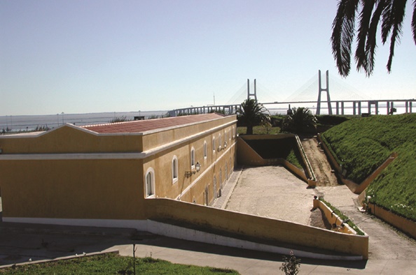
Small isolated fort from the 19th/20th century, it aimed to reinforce the garrisons of one of the defensive lines of the city of Lisbon. Its natural moat was the Trancão River. Nowadays, an Information System for the Architectonic Patrimony operates here, for the conditions needed for the preservation of gunpowder are the exact same of those needed to preserve documents.
Guided tours on the first Mondays of each month; April 18th and May 18th (Cultural Patrimony European Journeys)
Needs Scheduling (48 hours previous)
Free tours
Urbanização Real Forte
2685-141 – Sacavém
Phone: 219 427 788
Email: jnreis@dgpc.pt
GPS: Lat. 38° 47’ 45.429’’N, Long. 9° 6’ 8.266’’ O
Frielas Archeologic Place
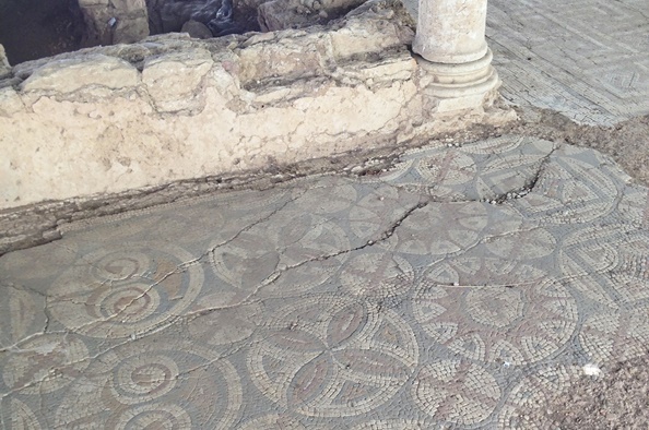
The Frielas Archeologic Place, classified as a place of public interest, has a villa of the Roman era, which architectonic component reveals a proprietor with relative purchase power. The ceramics, coins and decorative motives of the mosaics show the likes and buying strategies of the people that lived in this villa, from middle of the 1st century A.D. until middle of the 5th century A.D. The location of this place shows a perception of the resources available in there, promoting a subsistence based on agricultural exploitation, given the existence of fertile terrains, and on marine resources, given the presence of the river basin of the Trancão River.
We highlight the Santa Catarina Chapel, a contemporary building by king D. Dinis, from the 14th century, registering later reconstructions (17th – 18th centuries), probably after the earthquake, which was built over the Roman era structures.
Tours need scheduling
Free tours
Rua Quinta do Caiado
2660-066 Frielas
Phone: 211 150 673
Email: se_conventinho@cm-loures.pt
Website: www.cm-loures.pt
GPS: Lat. 38° 49’ 36.249’’N, Long. 9° 8’ 37.126’’ O